
Overnight hike in Appenzell: visit Säntis and Gasthaus Aescher
In short
-
Duration: 2 days
-
Distance: 23.5 km and 1800 height meters
-
Wildcamping: tolerated above the tree line
-
Seasonality: June – October
-
Public transport: Wasserauen (arrival) and Wildhaus dorf (departure)
-
Highlights: Appenzell, Säntis, guesthouse Aescher and Wildkirchcaves.
In June 2021 we decided to do a more touristic hike. We had been seeing a lot from switzerland in our exchange semester, but often skipping the touristic attractions due to the amount of people. This Appenzell – Säntis hike is a great example of how you can experience a touristic place, without having the touristic experience.
The hike
Seealpsee
We started our Säntis hike in Wasserauen hiking up a short while to Seealpsee. Seealpsee is one of the typical places where many people come just to take a picture. The beautiful blue lake sits at the end of a valley and mountains rise up on all sides. Numerous pitoresques traditional swiss houses decorate the lake shores, and the cows with bells make background music. Yes, a pretty perfect site. We arrived at Seealpsee as the start of our hike, and enjoyed some sun and a swim. Thereafter the real hike began, ascending up to Berggasthaus Aescher, which is also reacheable by cablecar. Quite some people descended this path, which caused the occiansional waiting time.
![Seealpsee surrounded by limestone cliffs in Appenzell [picture made by Emme Perreve]](http://hikersguidetoearth.eu/wp-content/uploads/seealpsee-view-appenzell.jpg)
Berghaus Aescher & Wildkirchcaves
Berghaus Aescher is actually cool. It’s one of the oldest swiss guesthouses and has exsisted in its present shape since 1860. It seems as if the guesthouse was taped stuck to a giant limestone rock face. Next to the berghaus there are the Wildkirchcaves, in which stone tools and bones of giant cave bears have been found. The inhabitation of the caves goes back to prehistoric when Neanderthals lived there. Long after them came the hermits, and there are stories of small wild people who helped the alpine dairy men. The four cavernous spaces have been shaped by millions of years of water erosion.
![Guesthouse Aescher at Ebenalp [picture made by Emme Perreve]](http://hikersguidetoearth.eu/wp-content/uploads/guesthouse-aescher.jpg)
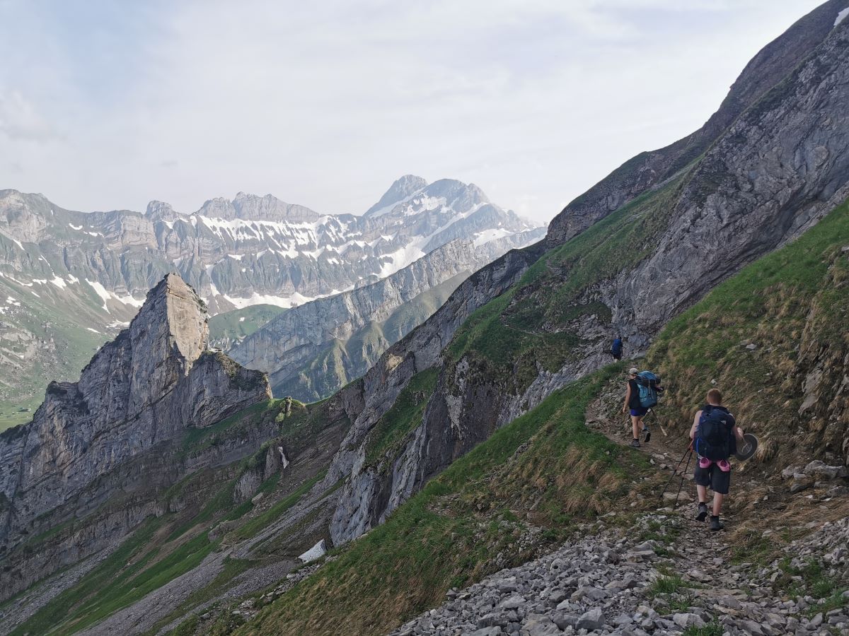
impressive mountain ridges
After our small excursion around the berghaus and the caves, we started hiking on a ridge, quickly leaving everyone behind us. This is often the case in the mountains: in a radius of 500m around cablecar stations it can busy, but further out, where it’s most beautiful, it’s extremely quiet. We hiked quite a long while along the ridge, which was way less technical as compared to our gäntrisch hike a few weeks before. The Säntis hike was beautiful with clear blue skies most of the time. We hiked through grassy fields, while rocks rose up all around us straight into the sky. The geology around säntis is very mesmerizing. Limestone, folded and thrusted so much, that the layering is often vertical instead of horizontal. It feels like you are surrounded by huge ridges of rock broken up into different pillars.
camping with a thunder view
We still had to cross a few snowfields, but most of them were melting fast and only around 10 cm thick. They were slippery, which made the experience of walking on them more playful as compared to previous hikes. We found a grassy plateau to camp on just before it got dark, not much below the säntis peak. The camping spot overlooked the valley all the way into the direction of zürich. Since the skies were clear we didn’t set up our tents, which turned out allright this time. However, i would recommend to always put up your tent, just in case it starts raining during the night. Since it was the first time we slept above the treeline and not in the vicinity of huts we couldn’t make a campfire. Instead we spend the night singing and playing ukulele and getting into our sleeping bags early.
![The almost vertical limestone layers close to Säntis [picture made by Sigmund Hennmum Høeg]](http://hikersguidetoearth.eu/wp-content/uploads/vertical-layering-santis.jpg)
![Crossing a snowfield right before the Säntis peak [picture made by Emme Perreve]](http://hikersguidetoearth.eu/wp-content/uploads/snow-crossing-santis.jpg)
Just before we fell asleep we could see thunderclouds moving closer to us. Somewhere above Zürich the lightning was striking, which was impressive to see. One of our friends, christian, got quite worried by now, seeing the thunder from a distance. Since the direct eyesight made it seem much closer, it felt like it could move into our direction fast. Where there was no shelter at all.. Thankfully swiss mountains have data almost everywhere, and therefore we could look up the weather prognosis. This eased his heart, showing that the thunder would stay in the valley and not move closer to the mountains.
Säntis
The morning of the second day we decided to hike up to Säntis and have breakfast there. The road had quite a few height meters and some snowfields to cross, which didn’t increase the efficiency. We needed to duck a fence to actually arrive on the säntis top, since the path we took was officially still closed due to the snow. We arrived on a very touristic place, which was an absurd experience after spending a night alone on a mountain peak. On säntis there’s a breakfast all-you-can-eat buffet restaurant with panoramic view and so many tourists it’s hard to navigate through them. The sun was coming up and we decided to take a spot in the middle of the viewpoint to make our oatmeal breakfast buffet. The tourists not used to the smelly humans that took so much space for a picknick, either looked at us like zoo animals or started chatting with us out of curiosity. After Säntis we shortly followed the ridge, this time without any snow. Upon leaving the ridge we ran into mountian goats before we arrived in Wildhaus for the journey back.
The route
How to get there
For the Säntis hike we started at the Wasserauen and ended at the busstop Wildhaus dorf. It takes you respectively 2 hours from and back to Zürich HB (main station). For a precise train schedule check the website of the swiss train company.
Good to know
- Wildkirchcaves – Don’t miss the highlight Wildkirchcaves, which are next to Berghaus Aescher.
- If you want a ridge hike with impressive geology, seeing some swiss highlights also without the tourists, this is the hike to do!
Best time to hike
We did hiked through Säntis in the beginning of june, and there was still some snow around (especially in between guesthouse Aescher and Säntis). It was not so much that it was dangereous, but it did slow us down on the hike. For a more accurate weather forecast check meteoswiss or SRF Meteo.
![Ridge surrounded by limestone outcrops around Säntis. [picture made by Emme Perreve]](http://hikersguidetoearth.eu/wp-content/uploads/santis-outcrops.jpg)
Geology
The area around Säntis has a very spectacular geology, due to the fold-and-thrust belt of the Helvetics nappes. The Helvetic nappes are a series of nappes in the northern part of the alps, and mostly consist of mesozoic limestones, shales and marls. These were originally deposited on the southern continental margin of the European continent, were a narow ocean, the Valais ocean, existed in between 66 – 250 Ma. The Valais ocean was part of the Thetys ocean, which separated the former supercontinent Pangea into Laurasia (containing europe) and Grondwana (containing Africa). 100 million years ago the extension of the Tethys Ocean stopped and the Apulian plate broke from Gondwana and moved toward the European continent. This resulted into the subduction of the western Tethys under the Apulian plate. Later on, this area became a convergent plate boundary, where the european plate subducted underneath the Apulian plate, which marks the start of the Alpine orogeny and the formation of the nappes.
The Helvetic nappes were broken apart by this compressional force, while being shoved over and folded on top of each other (this is called a fold-and-thrust belt). The folding and thrusting of the nappes is something that can be clearly seen in the area of Säntis, and has also been mapped by famous geologists like Albert Heim.
")

